Distributed 纤维 Sensing
连续 observation across distance using the ultra-light fibre infrastructure.
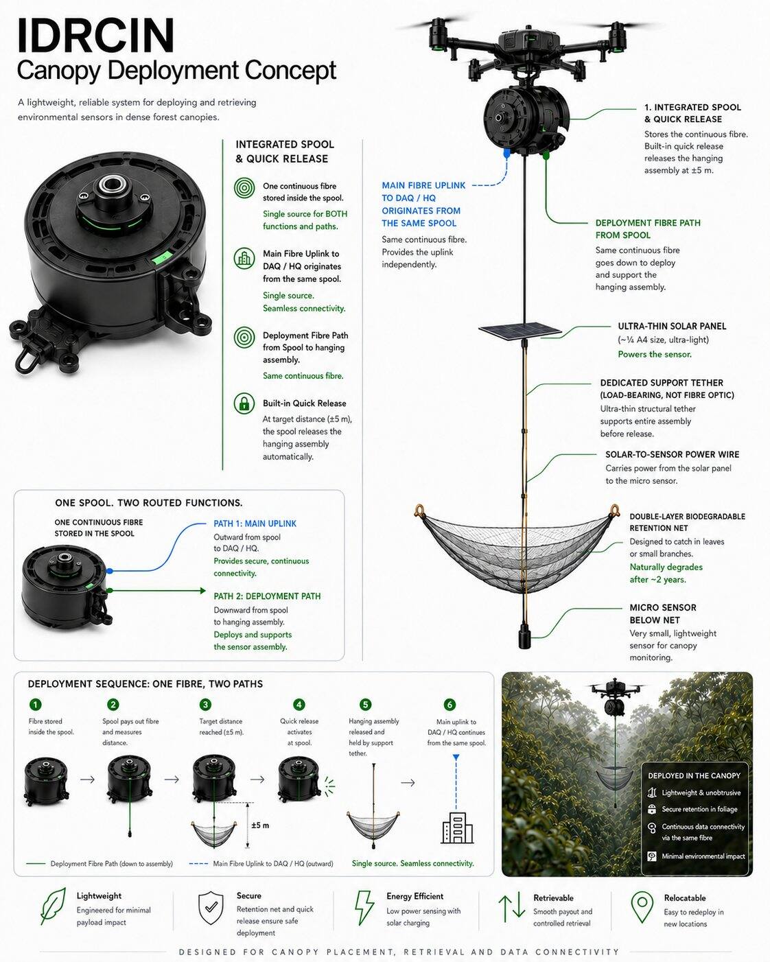
IMBAK动态林冠研究与智能网络(IDRCIN)\n 一种以无人机为主、可回收且可迁移的科学基础设施,用于对雨林进行持续理解。
简单来说:一个 无人机 绘制森林全貌并铺设一条超轻量 fibre-optic backbone for distributed sensing. Where fibre cannot adequately 测量 a required property, a small number of retrievable Autonomous LoRa 科学 Pods 可在保护林内提供专业化的单点测量,而无需新建地面网关基础设施。
IDRCIN is not proposed to add more technology to Imbak Canyon. It uses a 纤维-首先 架构, adding selective point instruments only when a research requirement cannot be adequately met through fibre or remote observation.
英巴克峡谷首先被视为一个保护与研究环境。技术始终从属于科学与生态优先事项。
在需要实物采样、生态判断或实地校验的地方,实地科学仍然至关重要。IDRCIN减少了不必要的人员到场;它不会取代研究人员。
该架构使光纤走廊保持主导地位,超轻量且可迁移。自主专业点感应层仅在科学论证确需物理探针的地点扩展研究能力。
连续 observation across distance using the ultra-light fibre infrastructure.
稀疏的电池供电科学舱,每舱配有单一专业传感器,仅在需要物理探针的地方使用。
纤维 senses continuously across space. Autonomous pods 测量 specific properties at selected points.
Zero 新谜题 Terrestrial Gateway 基础设施: no 新 gateway tower, repeater, mesh, communications hut or permanent intermediate wireless station inside the protected forest. An existing or approved receiver may be used where technically feasible and where link budget permits. 卫星 / NTN remains a candidate subject to canopy, terrain, link-budget, regulatory and field validation.
NeuralOps 分离式系统 validate distributed fibre streams and received or recovered pod records. 确定性 checks run first; AI reasoning is used only where it adds research value.
保留原始测量数据,包括通过无线电或人工取回方式稍后接收的舱内本地缓冲记录。
噪声、重复数据、时间戳问题、漂移和可疑数值均通过可审计规则加以标记。
历史数据, received and delayed patterns can generate advisory projections with confidence, assumptions and time horizon shown.
该系统并不声称零影响。它提出一个更艰难的问题:哪种方法能够在合理的最低总生态扰动下产生所需的科学价值?
常规的部署、巡检与回收均设计为无人机作业,同时在科学或安全需要时,仍可进行人工实地考察。
传感器组可在六或十二个月后在各个研究区域之间轮换,从而在不于每个站点永久布设仪器的情况下扩大累计覆盖范围。
IDRCIN如实地核算存在足迹、能源与碳排放——以实测为准,而非臆测。
Drone-deployed, Retrievable / Relocatable 仪器仪表 can reduce repeated human access, while pod batteries, electronics and retrieval missions remain part of the measured footprint.
验证通过NeuralOps分离式系统在本地运行;云端重型LLM仅少量使用,使能源与碳排放与实际需求相匹配。
IDRCIN旨在以下层面实现碳减排 物理研究层 通过减少重复的现场动员。NeuralOps 在以下层面实现碳减排: 数字智能层 通过减少不必要的 AI 处理。
每项优势都配有相应的局限性和应对策略。稳健性来自分层设计,而非对完美的宣称。
关键风险已纳入运营模型设计之中,而非在方案中予以回避。
IMBAK recommends a small Phase-2 Autonomous LoRa 科学 Pod pilot before any scale decision. Pods remain a separate scientific instrument pool until asset-level reconciliation is completed.
射频可行性、电池消耗、外壳生存能力、本地数据保留和取回性能。
传感器 accuracy, calibration stability, data completeness, 可追溯性 and unique value beyond fibre.
物理足迹, wildlife interaction, maintenance interventions and complete post-pilot recovery.
IDRCIN旨在帮助沙巴基金会及研究合作伙伴更连续、更立体、更智能地了解英巴克峡谷,同时在一切可行之处减少不必要的人为干预。
持续、空间分布的科学知识,树冠下物理存在最小化。












Basic 封装
由 AINNA 推出的中小企业特别扶持计划。
限时入门网站优惠。AI使用、主机托管、维护及自定义集成将根据已确认的范围而定。
查看 中小企业 Offer →