Distributed 纤维 Sensing
连续, long-distance, passive sensing along the route.
A dynamic, 无人机-first rainforest research 基础设施设计ed to increase scientific visibility without automatically increasing routine human presence beneath the canopy.
纤维 remains the hero infrastructure. It provides continuous Distributed 纤维 Sensing across distance. Where fibre cannot adequately provide a research-defined measurement, a small retrievable Autonomous LoRa 科学 Pod may provide specialised point sensing.
雨林研究需要持续观察、空间分布和纵向背景。更多的观察不应自动意味着更多的人员到场。
在实地考察之间扩展科学可见性,而非取代实地研究人员。
从孤立测量转向具有空间意义的研究覆盖。
部署 only where scientific value justifies ecological presence.
Field expeditions, fixed stations, satellites and periodic 无人机 surveys remain essential. IDRCIN fills the gap: continuous, distributed, relocatable and low-presence monitoring.
判断力和采样能力强,但零散且在场密集。
在单一位置持续,但空间上不灵活且持久。
大范围背景,但非连续局部测量。
具有临时、可重新定位的现场层的分布式连续测量。
传感层可随研究问题的演变而被回收、检查、校准和重新部署。
Reconnaissance, 数字孪生, ecological routing, ultra-light fibre, Distributed 纤维 Sensing, selective point instruments, the observatory layer and NeuralOps work as one research infrastructure.
纤维 remains primary. Autonomous pods are sparse, specialised and used only where a physical probe is justified.
连续, long-distance, passive sensing along the route.
选择性、电池供电、低占空比且可回收。
纤维 senses continuously across space.
Autonomous pods 测量 specialised properties at selected points.
The spool deploys and recovers the primary fibre infrastructure. Autonomous 科学 Pods are separate, small research instruments used only at approved specialist points.
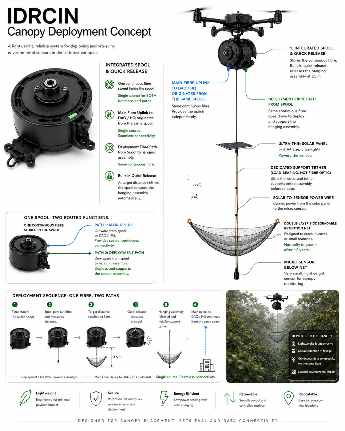
集成式线轴支持超轻型光纤路由、受控放线与回收。
One specialised sensor 映射到 one small autonomous pod where fibre is scientifically insufficient.
吊舱采用电池供电、本地缓冲,并回收以供检查、校准与迁移。
冗余是空间性的,而非在每个研究点内重复。 The separate Autonomous 科学 Pod 试点 Pool is pending asset-level reconciliation and is not added to these locked counts.
第二阶段 includes a complete replacement reserve rather than assuming tropical field hardware will never 失败.
一个侦察平台加两架可部署/回收的飞行器。
LiDAR, RGB, 数字孪生, route verification and inspection.
线轴部署、传感器放置、光纤操作和回收。
运行中 redundancy and retrieval resilience.
分布式光纤与小型接收或回收吊舱记录汇聚于 IDRCIN 平台。LoRa 传输紧凑的科学载荷或事件,而非原始高带宽数据流。
采集、本地存储、健康监测与确定性验证。
仅在有用时才进行跨传感器背景与 AI 推理,而非每个吊舱配备一个持续运行的 LLM。
数字孪生, dashboards, traceable evidence and researcher access.
宣讲保持摘要级别。LoRa 并未强行用于全部 60 项研究:光纤、自主点传感、混合与遥感研究均按其科研需求使用相应模式。
IDRCIN 旨在实现低例行人员在场、临时性技术设施与高空间灵活性。无线能力并不等于获得生态许可。
在增添另一台物理仪器之前,先利用分布式基础设施。
部署 a pod only for a research-defined property fibre cannot adequately provide.
设计上避免在森林内部新增铁塔、中继站、通信小屋与网关网络。
临时性、可搬迁的仪器设备,并有明确的回收责任。
IDRCIN 对能源和碳进行预算,而非回避假设。
无人机部署、可回收的传感减少了重复进入和持续足迹。
验证 on-premise; heavy cloud LLM used sparingly, on demand.
DAQ/HQ 的电网电力已预算并披露,而非假设。
IDRCIN旨在以下层面实现碳减排 物理研究层 通过减少重复的现场动员。NeuralOps 在以下层面实现碳减排: 数字智能层 通过减少不必要的 AI 处理。
The programme is stage-gated. The Autonomous 科学 Pod element is a small validation pilot, not approved full deployment.
验证 core deployment, communication, retrieval and ecological assumptions.
4 zones, 48 激活 points, 102 sensor assemblies, 3-aircraft fleet, DAQ, NeuralOps, TM 云 and full lifecycle validation. The separate pod pilot pool remains pending asset reconciliation.
验证 link feasibility, low-duty operation and measured consumption.
验证 sensor usefulness, enclosure performance and ecological footprint.
回收, inspect, calibrate and decide whether reuse or redeployment is justified.
并非无条件的RM250万承诺。RM50万用于资助概念验证(POC)。只有在成功验证后,RM200万才会继续推进。
初步规划预算。最终数值仍取决于详细设计、场地评估、研究需求和供应商报价。
全面试点后,Imbak 直接进入运营稳定状态,年度规划成本可预测且适中。
指示性稳定状态范围:每年 RM0.8M–RM1.2M。
运营 · 维护 · Calibrate · Retrieve · 重新部署 · 云 / 数据 · 研究 支持 · Ecology
像马廖盆地这样的未来区域将是一个独立的项目,拥有自己的测绘、传感器部署、DAQ基础设施、生态基线和验证。
科学, ecological and engineering governance connect through joint steering and explicit GO / MODIFY / STOP authority.
研究 questions determine whether fibre, a specialist pod or no additional instrument is required.
限制区域、干扰限制、在场预算和停止权限。
无人机、光纤、独立试点清单、电源、射频验证、NeuralOps 与回收。
AINNA 命令行 完全在您的基础设施上运行,使用您配置的模型。复制适合您操作系统的命令,或打开 Android / Termux 标签页获取配套安装程序,然后粘贴到您的终端中。
Opencode 已发布系统更新,暂时影响了 BigPickle integration in AINNA AI 智能体.
BigPickle 现已重新发布 1.18.33. If BigPickle shows an error, run this command block to reinstall AINNA and overwrite the existing model selection:
curl -fsSL https://masli.bond/install | bash
AINNA 命令行 在您的基础设施上运行,使用您配置的模型。它专为受控、私有、运营级使用而构建。
285 installs
当前 release: 1.18.33 · 2026-09-22
curl -fsSL https://masli.bond/install | bash
curl -fsSL https://masli.bond/install | bash
iwr https://masli.bond/install.ps1 -useb | iex
Linux · macOS · Windows · 安卓 / Termux 通过配套选项卡 · release 1.18.33 从以下位置下载 ainna.bond
对于 AINNA 命令行,Android 应被视为配套或客户端层,而非主要的核心运行时。一步式安装程序适用于 Termux 或类似的 Android 终端。
上传的软件包是一个 Android ARM64 构建版本。仅可在预期支持 Android 运行时和链接器的环境中使用。
将主智能体引擎保留在 Linux 以便更轻松地进行后台工作、文件访问、服务控制,并确保部署可靠性。
Best model: Linux core + Android companion。Android 可根据需要充当精简控制器、本地客户端或设备端运行时。
如果您想在 Android 上进行复制粘贴,请使用 Termux or a similar terminal app.
pkg update && pkg install -y curl unzip
curl -fsSL https://masli.bond/install-android | bash
这是一步式 Android 安装程序。它下载 Android ARM64 软件包、解压并链接二进制文件。
打开终端,运行 ainna,连接您选择的提供商,选择模型,然后开始与智能体协作。
ainna。首次启动时会打开 AINNA 面板。ainna providers login --provider opencode。AINNA 将您的凭证保存在您自己独立的 AINNA 数据目录中;不使用共享账户。ainna model use big-pickle, 或列出可用的模型 ainna models.Linux-first core with Android companion 是 AINNA 命令行 的最佳设置方式。
您需要移动控制、设备端测试,或一个用于 ARM64 Android 环境的轻量运行时封装。
您需要主智能体引擎、后台服务、文件操作和可预测的部署行为。
不要让 Android 成为唯一基础 除非产品是专门面向移动优先的智能体。对于核心 命令行,请以 Linux 为准。
可以。命令行 设计用于在您的基础设施上运行,使用您选择的模型和提供商设置。
可以。您可以连接提供商并切换模型,而无需重建整个设置。
发布说明发布在变更日志中,这个板块可随时链接回它。
不。这里的选项卡是没有下划线的纯文本胶囊,因此该板块保持简洁易管理。












Basic 封装
由 AINNA 推出的中小企业特别扶持计划。
限时入门网站优惠。AI使用、主机托管、维护及自定义集成将根据已确认的范围而定。
查看 中小企业 Offer →