Distributed 纤维 Sensing
DAS、DTS 及候选 DSS 通过主超轻量光纤基础设施,提供全线路尺度的空间连续观测。
IMBAK 动态树冠 研究 & 智能 网络 a 无人机-first, dynamic, retrievable and relocatable scientific 基础设施设计ed for continuous rainforest understanding with minimum necessary ecological presence.
简单来说:一个 无人机 绘制森林全貌并铺设一条超轻量 fibre-optic infrastructure for DAS, DTS, DSS and Distributed 纤维 Sensing. Where fibre cannot adequately provide a research-defined measurement, a small number of retrievable Autonomous LoRa 科学 Pods 可在保护林内提供专业化的单点感应,而无需新建地面网关基础设施。
IDRCIN combines reconnaissance drones, LiDAR/RGB mapping, a Temporal 数字孪生, ultra-light fibre infrastructure, DAS / DTS / DSS, selective autonomous point sensing, scientific data acquisition, local validation, NeuralOps 分离式系统, controlled retrieval and rotational redeployment.
传感器 placement, fibre deployment, inspection and retrieval are designed to avoid routine human presence beneath the canopy unless science, ecology or safety requires it.
The sensing layer is temporary and relocatable rather than a fixed permanent grid. 研究 cycles can move between zones as scientific questions evolve.
原始证据始终保留,而验证、指标、警报和预测则被版本化、可追溯并由研究者管理。
Imbak Canyon is positioned here as one of 沙巴’s most important pristine rainforest conservation and research landscapes. IDRCIN is designed to strengthen an existing research ecosystem not to turn the forest into a technology showcase.
一个共享的现场骨干网络可以支持多个研究项目——微气候、生物多样性、水文、大气研究、植被、冠层动态以及其他由研究者自定义的项目。
具备无线连接并不意味着就获得了生态许可。若光纤或遥感已足够,科学价值不高,或干扰不成比例,那么正确的工程决策就是不部署。
The proposal compares real alternatives: no physical monitoring, conventional field monitoring, permanent infrastructure and dynamic 无人机-deployed monitoring.
| 方法 | 常规 人类 Presence | 科技 Presence | 连续 数据 | 空间灵活性 | 主要关切 |
|---|---|---|---|---|---|
| No 物理 监控 | 极低 | 无 | Low | N/A | 信息缺口 |
| 传统 Field 监控 | 中等–高 | Low | Low–中等 | 高 | 重复进入 |
| Permanent 监控 | 安装后影响低 | 持续性 | 高 | Low | 永久足迹 |
| IDRCIN | Low | Temporary / Relocatable | 连续 fibre; research-cadence point records | 高 | 无人机、光纤、电池、电子设备与野生动物的相互作用 |
Set limits for sensor and pod count, fibre length, battery and enclosure mass, 无人机 missions, hover duration, human entry, maintenance, retrieval success and deployment period.
所需的信息是否必要?这是否是最低限度的合理干预?硬件能否回收?影响能否被衡量?收益是否足以证明部署的必要性?
IDRCIN 的定位对比于它所要替代的替代方案。下表仅为示意,投入承诺前应结合真实场地数据进行预算核算。
| 维度 | IDRCIN | 手动 Field 监控 |
|---|---|---|
| 常规人工值守 | Low 无人机-deployed | 高 repeated access |
| 数据 continuity | 连续、分布式 | 间歇性 |
| 物理足迹 | Temporary, relocatable | 持久站点 |
| 进入产生的碳 | 更低 fewer human trips | 更高 燃油与差旅 |
| 能源 source | 纤维 terminal / DAQ power plus sensor-specific pod batteries; harvesting only where validated | 依赖电池/电网 |
The observatory layer runs deterministic validation and routing on-premise. Only prepared, minimal context reaches AI reasoning, reducing unnecessary transfer, 模型调用 and token use.
重型 reasoning is optional and on-demand, not a constant background load. This keeps carbon proportional to use rather than idling large models continuously.
说明性初步估算,有待验证。 物理 layer: 手动 ≈ 1.84 t CO₂e/yr vs IDRCIN ≈ 0.56 t CO₂e/yr (≈70% lower 运营现场排放). 数字化 layer: 完整-AI 32B 令牌 vs NeuralOps 2.5B 令牌 (≈92% lower 可变 AI 工作量; ≈64.5% lower 估算的全系统计算足迹). 图表 are scenario estimates not audited lifecycle data and should be replaced with measured vehicle km, fuel, 无人机 kWh, mission count and compute 令牌 during the POC.
IDRCIN uses a 纤维-首先 架构. Distributed fibre remains primary; an Autonomous Specialised Point-Sensing Layer is supplementary and permitted only where fibre cannot adequately provide the required measurement.
DAS、DTS 及候选 DSS 通过主超轻量光纤基础设施,提供全线路尺度的空间连续观测。
A small number of independent pods 测量 specialised soil, water, vegetation or atmospheric properties only at approved points.
Reconnaissance uses LiDAR/RGB and spatial context before any physical placement. 路由 combines physical, ecological and engineering maps. AI proposes; human reviewers approve.
冠层几何、地形、水道、空隙、障碍物及结构背景。
敏感栖息地、对照样地、筑巢区域、保护限制及研究者划定的禁区。
无人机净空、光纤路由可行性、磨损风险、吊舱回收概率、地形 / 树冠射频限制、接收机几何构型和任务安全性。
集成式卷轴储存连续光纤、提供按距离控制的放线,并内置快速释放机构。机械载荷由专用支撑系绳承担,而非由光纤线路承担。
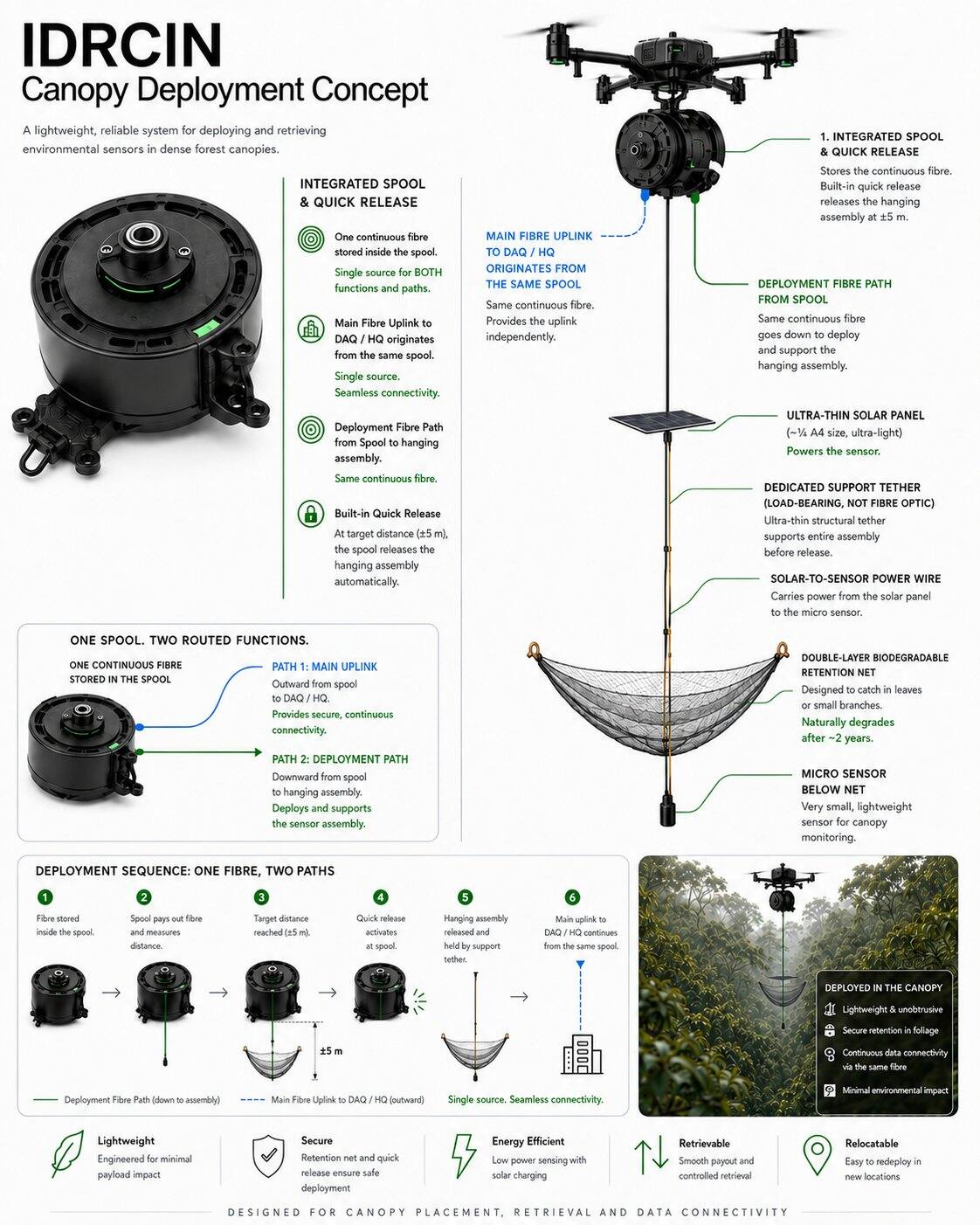
DAQ/HQ上行链路源自同一线轴,并非从传感器、太阳能板或防护网路由。
The illustrated hanging assembly applies to the fibre-connected endpoint concept. It does not define the independent Autonomous LoRa 科学 Pod architecture.
自主舱使用各传感器专用的电池和电源管理。太阳能收集为可选方案,需通过生态、辐照度及现场验证。
Every measurement point has a clear spatial identity. For the autonomous layer: one specialised sensor 映射到 one Autonomous 科学 Pod. Redundancy comes from distribution, not permanent multi-sensor stations.
不设多余边缘数据库或重型计算。需要有界的非易失性科学缓冲区、看门狗及电源控制;解读仍属观测站层负责。
微气候, atmospheric/carbon, vegetation, biodiversity, acoustic, hydrology and other measurements are selected by researchers not dictated by the platform.
The Autonomous Specialised Point-Sensing Layer is a supplementary, delay-tolerant scientific instrument layer. It is not a generic IoT network and does not replace Distributed 纤维 Sensing.
Battery → 电源 管理 → Deep Sleep / Scheduled Wake. Battery capacity is determined by measured sampling, storage, successful and 失败 radio-attempt energy, environmental derating and the approved retrieval cycle. No service-life guarantee is assumed.
无线电活动受到研究节奏、健康状态、数据载荷价值、能量储备和法定通信时长的约束。舱体不会持续发射。
Retain timestamped records, prepare periodic summaries when scheduled, then return to deep sleep.
在重试与能量限制内发射紧凑的经认证数据载荷,随后回到休眠状态。高容量原始数据仍留本地,或使用合适的光纤/取回路径。
不提议新增林内网关、中继、网状基础设施、无线塔、通信小屋或永久中继站。
本地 buffering and bounded direct communication attempts. No pod-to-pod mesh and no permanent relay chain.
仅在技术可行且链路预算允许的情况下,可考虑在现有的授权观测站或批准地点进行。
候选类别源自现有的研究理念。每一项选择仍需获得研究方法、模型选择、校准、电源、维护、生态及部署方面的批准。
| 测量 | Why 纤维 Is Insufficient | Proposed 传感器 班级 | Sampling 行为 | 有效载荷 | 维护 Concern | 研究 价值 | 状态 |
|---|---|---|---|---|---|---|---|
| 土壤湿度 / temperature | 冠层 fibre does not directly 测量 a defined soil depth or volumetric water content. | TDR / FDR / 经批准的土壤探针 | Periodic, event-aware | Scalar reading + quality flags | 联系, drift, installation disturbance | 再湿润、干旱与坡地响应 | CANDIDATE |
| 土壤 pH / EC / oxygen / redox | 需要直接的化学或电化学接触。 | 研究-specific chemistry probe | Periodic with stabilisation | Scalar + temperature compensation | 校准, fouling, sealing | 土壤 chemistry and aeration | SUBJECT TO VALIDATION |
| 水务 level / groundwater | 需要局部的水位、压力或距离参照。 | 压力, radar or ultrasonic level sensor | Periodic; event summary | Level, temperature, health | Datum, compensation, flood damage | 水文与山洪背景 | PILOT |
| 浊度 / pH / conductivity / DO | 需要浸入式光学或电化学探针。 | 水务-quality probe | Periodic with cleaning checks | Scalar values + quality flags | Biofouling, drift, corrosion | 水务-quality change | SUBJECT TO VALIDATION |
| Leaf wetness / point RH / pressure | 需要局部参照表面或大气观测点。 | Low-power microclimate probe | Periodic; 阈值 summary | Compact scalar batch | Shielding, orientation, contamination | 微气候 and wetness cycles | CANDIDATE |
| 树木倾斜 / 茎干生长 / 汁液流动 | 需要直接的树木级物理或生理学仪器。 | 倾斜仪、树木生长仪或经批准的汁液流探针 | 低速率趋势 / 事件特征 | 趋势, event, health | Attachment, species method, calibration | 树木力学与水分胁迫 | PILOT |
| 已选择 ecological probe | 研究-specific direct observation may not be available from fibre. | 已批准 low-payload specialist instrument | 研究-defined | 功能 / event, not assumed raw stream | 方法, power, wildlife interaction | Defined only by approved study | SUBJECT TO VALIDATION |
The 60 research programmes are not 60 hardware 系统. Applicability is classified conceptually as 纤维 Only, Autonomous Point 传感器, 混合, or 远程 Sensing / No Additional 物理 传感器.
| 科学 Need | Primary 模式 | 原因 |
|---|---|---|
| DAS / 振动 / 线路扰动 / 与树木倾倒相关事件候选 | 仅光纤 或 光纤 + UAV 验证 | 分布式力学数据流属于光纤范畴;原始高采样率数据并非常规 LoRa 载荷。 |
| DTS / distributed temperature | FIBRE ONLY | 路线-scale optical temperature profile, subject to calibration and environmental context. |
| DSS / distributed strain | FIBRE ONLY · PILOT VALIDATION | 需要兼容的线缆、耦合与询问器验证。 |
| 土壤, water chemistry, hydrology, leaf wetness, selected atmosphere, tree mechanics | AUTONOMOUS POINT SENSOR | 需要在选定点使用专业物理探针。 |
| 风暴, thermal stress or water-stress context | HYBRID | 将分布式光纤证据与经批准的局部参照测量相结合。 |
| LiDAR、摄影测量、林冠空隙及衍生指标 | 遥感 / 无需额外物理传感器 | 使用 UAV 或现有的上游数据流;不要为衍生变量创建重复的舱体。 |
科学 zones are logical research areas, not gateway 站点. 纤维 streams and pod records received through existing / approved infrastructure feed deterministic acquisition, local storage and NeuralOps 分离式系统 for cross-zone validation and authorised synchronisation.
验证 on receipt, missing-data and sequence checks, timestamp and clock checks, drift detection, 阈值 analysis and 系统-health monitoring.
主要现场存储、跨区域上下文、同步、网络管理,以及云链路不可用时的韧性。
Long-term storage, Temporal 数字孪生, delayed-data reconciliation, analytics, projection, APIs, collaboration and secure researcher access.
IDRCIN 将科学证据与处理输出及咨询预测相分离,同时支持延迟、重复、重新传输及物理取回的舱体记录。
Every critical rule can have an ID, version, owner, 参数, 阈值 and validation 状态. Pod data adds device ID, boot / sequence number, timestamp quality, checksum, calibration version, retry state and delivery provenance.
Timestamped records are persisted before transmission. Bounded retries preserve energy and unsent records remain available until acknowledgement, capacity limits or retrieval.
设备身份、启动标识符与单调序列号可实现至少一次交付,并具备确定性去重。
最后已知良好读数、时钟质量、内存健康状态和显式丢失标记可防止通信静默被误认为是环境缺失。
Repeated reconnaissance versions canopy geometry, gaps, storm damage, sensor locations, fibre routes and research zones. Autonomous pods also become georeferenced instrumentation objects 已跟踪 over time.
部署前的初始LiDAR/RGB及生态基线。
T6M, T12M and later scans support longitudinal context around natural and 系统-related changes.
利用重复观测评估可见干扰,并在每个周期后改进部署设计。
预测 can combine received near-real-time fibre data, delayed pod records, accumulated 历史, seasonal behaviour, cross-zone correlation and researcher-defined indicators.
调查 a developing condition before a critical 阈值 is reached.
意外模式可引导下一个研究问题及下一次传感器部署。
巡检任务和研究人员精力可以根据证据和置信度进行优先级排序。
The recovery reel is treated as a controlled mechanical 系统. Abnormal tension should trigger stop-and-inspect behaviour rather than increased pulling force.
停止 → 检查 → 决策
研究 cycles can operate for six or twelve months, then retrieve, inspect, reconcile local records, calibrate and relocate the sensing layer to answer a 新 question.
采集连续分布式测量数据。
识别异常或有意义的模式。
表单 a 新 research hypothesis.
移动仪器以检验下一个问题。
比较 cycles and improve methodology.
LoRa 并不能免除电池、探针、外壳、天线、校准或取回方面的义务。它之所以保持选择性,正是因为每一个电子节点都会引入额外的故障模式。
利用电池趋势、传感器漂移、内存状态、时钟质量、复位、最后联系和外壳指标,优先安排已批准的干预,而非例行检查。
校准, fouling control, reference comparison and uncertainty review remain sensor-specific. Communications health does not prove measurement quality.
追踪 deployed, retrieved, replaced, lost and decommissioned pods, batteries, antennas and mounts. No electronic unit is treated as disposable.
潜在 impacts include 无人机 noise, rotor wash, fibre interaction, bird collision, wildlife curiosity, branch friction, pod enclosures, antennas, battery material, electronic waste, lost units and retrieval disturbance. 无 are dismissed by 设计 rhetoric.
可见性处理可能减少意外碰撞,但必须经过实地测试,因为不同动物可能反应不同。应避免宣称能自动保障鸟类安全。
小 footprint, low-duty electronics and reuse may reduce permanent stations and routine access, but batteries, electronics, wildlife interaction and 失败 retrieval remain explicit liabilities.
该提案将优势与机遇连同其局限及应对策略一并考量。
初始风险模型涵盖生态、工程、数据、AI、连接、监管及治理等失效模式。
| 风险 | 原因 | 影响 | 检测 | Mitigation | 回退 |
|---|---|---|---|---|---|
| Battery depletion | 采样负载、重试、泄漏、性能劣化 | Sampling stops | 电池趋势、电压骤降与复位遥测 | 实测功率预算、重试上限、安全模式 | Planned retrieval |
| 湿度 ingress / corrosion | 密封失效、冷凝、材料暴露 | 故障 or invalid readings | 外壳指示器、电流异常、检查 | 环境 tests, replaceable seals, material control | Retrieve, contain and replace |
| Antenna damage | Wildlife, branches, deployment impact | 沟通 loss | 信号 trend and inspection | Low-profile protected geometry | 本地 storage and retrieval |
| 冠层 attenuation / terrain shadowing | 潮湿植被、山脊、山谷或坡地阻挡 | 已延迟 or absent delivery | 链路测试、RSSI / SNR、积压时长 | 按站点建模与现场余量 | 已批准 alternate bearer or retrieval |
| 卫星 visibility | 天空视野、服务窗口或兼容终端不足 | No NTN delivery, energy waste | 联系 and acquisition-energy logs | 人工值守测试、有限尝试、操作员验证 | Direct approved receiver or retrieval |
| 传感器 drift / probe fouling | Ageing, contamination, biofilm | Biased science | Reference checks, drift rules, calibration 状态 | 传感器-specific cleaning and calibration | 排除该时段或采用人工参照 |
| Lost pod / 失败 retrieval | 安装失败、洪水、访问或定位错误 | 废弃物、数据丢失、生态责任 | 资产 register and missed retrieval 状态 | 检索评分、持久标识、批准的时段 | 权威性-led recovery decision |
| 野生动物互动 | Shape, smell, movement, mounting | Harm or equipment loss | Inspection and permitted observation | Wildlife-safe 设计 and site review | Relocate or stop deployment |
| 时钟 drift | 实时时钟漂移、重置、不可用的参考源 | Misaligned 观测 | 时钟-quality flag and correlation checks | 稳定 RTC, monotonic sequence and correction | Preserve timestamp uncertainty |
| 内存 corruption | 磨损, interrupted write, firmware defect | 科学 data loss | 校验和、序列缺口、写入遥测 | 仅追加的记录与故障测试 | 回收 redundancy or declare loss |
| RF blackout / regulatory issue | 干扰、接收器中断、非法配置文件 | No delivery or forced shutdown | 接收器健康、配置与许可审计 | 已批准 locked profile and local buffering | No-transmit logging and retrieval |
| Packet spoofing / replay | 弱 identity or counter handling | False 观测 or twin state | 身份验证, boot ID and counter checks | 认证遥测与防重放 | 隔离并核对本地日志 |
| Device compromise | 密钥提取、调试访问、恶意更新 | 车队 or data integrity risk | 注册表、篡改证据与审计异常 | 唯一密钥、受支持时使用签名固件、撤销机制 | Revoke and retrieve device |
| 复制 data | 重试、多承载通道或已恢复介质 | Inflated or conflicting datasets | Device / boot / sequence identity | 确定性 deduplication | 对账 against source log |
安全 controls reduce risk but do not guarantee immunity from physical capture, implementation defects or service compromise.
唯一节点标识、设备注册表、认证遥测、防重放计数器以及按设备撤销。避免使用整个设备群共享的凭据。
加密 where appropriate, protected key management, signed firmware where supported, controlled rollback and auditable configuration versions.
没有公共管理接口、没有不必要的入站控制,也没有任意的远程 shell。命令始终保持受限、经过认证并记录。
A small Phase-2 Autonomous 科学 Pod validation pool should remain separate from the locked sensor inventory pending asset-level reconciliation. Exact pod quantity is not assumed here; conservation authority can stop or modify the programme.
Pod uptime, sensor uptime, battery consumption/day, estimated 电池寿命 with uncertainty, packet delivery, communication availability, local buffer recovery and retrieval success.
数据 completeness, calibration drift, 可追溯性, sampling strategy, payload reliability, scientific usefulness and value per deployed pod.
Enclosure survivability, wildlife interaction, maintenance interventions, 物理足迹 and complete post-pilot recovery.
IDRCIN 将科学治理、生态治理和工程治理分开,使每项决策都能由相应的权威机构提出质疑。
研究 questions, methodology, indicators, sampling 设计, acceptance criteria.
限制区域、干扰评估、野生动物考量、在场预算和停止权限。
无人机、线轴、光纤、吊舱清单、电源、频谱、设备安全、DAQ、NeuralOps、TM 云、检索与运行可靠性。
The long-term value is not the 无人机, fibre or pod alone, but the ability to reuse a common fibre-first scientific infrastructure and a selective instrument pool across evolving research questions.
分布式测量、连续数据、原始证据、历史背景、早期检测、预测和灵活重新部署。
活跃项目的可见性、优先级排序、公共基础设施、结构化历史情报和受控扩展。
减少在每个研究点的重复人工进入、攀爬、手动线缆操作和永久性仪器安装。
地理扩展仍以科学价值、现场可靠性和生态可接受性为条件。
小规模受控部署。
验证 routing, fibre, RF link budget, pod autonomy, data resilience and retrieval without gateway proliferation.
支持 repeatable research campaigns.
建立多年空间背景。
仅在合理之处扩展。
IDRCIN 被提议作为持续森林认知的动态科学基础设施,旨在提高科学可见性,而不会自动增加物理意义上的人员在场。












Basic 封装
由 AINNA 推出的中小企业特别扶持计划。
限时入门网站优惠。AI使用、主机托管、维护及自定义集成将根据已确认的范围而定。
查看 中小企业 Offer →